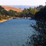
Within this 2,315-acre Point Pinole Regional Shoreline Park, the largest on the northeast bay shore, you’ll find a variety of habitats; meadows, marshlands, rocky beaches, while views of Mt.Tamalpais, the Marin shoreline, and San Pablo and San Francisco Bay stretch before you. Wildlife is abundant, over 100 species of bird can be found in two of the bay’s remaining original salt marshes, sandy shores and eucalyptus groves.
A map available at the entrance shows 12 miles of trails (at least five miles have some access) that crisscross the park. From the 1,250-foot fishing pier at the end of Pinole Point Road you can see remnants of the old pier that stretched for 900 feet into San Pablo Bay, and was once the busy shipping dock of Atlas Powder Company: Four different manufacturers produced two billion pounds of gunpowder and dynamite here from 1880 to 1960 and some trail names bear witness to the park’s explosive past (Nitro, Angel Buggy, Packhouse). In summer most of its grassy areas are dry and it can be hot, but in winter and spring, it may be the best hike one can reach by public transit.
Pinole Point Road
see access criteria for definitions
- Trailhead: At parking lot
- Length: 1-2 total miles
- Typical Width: 4 ft. & above
- Typical Grade: Mostly level or gentle
There are two steep stretches; one at the start where the trail climbs to a railroad overpass; the other near the trails end. - Terrain: Hard
Description
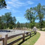
Pinole Point Road (closed to automobile traffic) the main route through the center of the park, leads to the end of the point and fishing pier. It’s the only paved trail and can be crowded with people walking their dogs, kids on bikes and fisherman heading to the pier. It starts from the parking lot with a climb over a railway overpass that may require assistance for a manual chair user, then runs almost level until it dips and climbs for a few hundred yards as it approaches the pier. Benches are available all along the way as well as pleasant picnic areas with moderately accessible tables and barbecues.
Owl Alley
see access criteria for definitions
- Trailhead: Northern entrance; near picnic area by pier. Southern entrance; follow Giant Station to Cooks Point Trail, then Owl Alley.
- Length: 1-2 total miles
- Typical Width: 4 ft. & above
- Typical Grade: Gentle
- Terrain: Firm
Gravel surface may be rough in places. Some patches may be impassable in wet weather. The spur trail to the pond has a steep cross slope.
Description
We started at the southern entrance paying close attention to trail signage; it’s easier to follow from the north entrance. Owl Alley Trail parallels Pinole Point Trail further inland offering views of San Pablo Bay and the hills beyond. Much of this trail has expansive views of the grasslands until you reach a eucalyptus grove where, from Dec. thru Feb. you might catch a glimpse of Monarch butterflies. A small fresh water pond lies down a spur trail at about the halfway point between the trail’s north end and where it connects to Cook’s Point Trail. It’s a lovely private place to linger and listen to frogs. Just beyond the pond we were treated to an amusing show of goats busily munching the grasslands; they are brought in yearly to mow the grasses.
You can make an easy three to four mile loop when one combines it with Point Pinole Trail and Cook’s Point Trail. Benches are provided.
Cook’s Point Trail
see access criteria for definitions
- Trailhead: Start from the Giant Cluster picnic area. Sign says Giant Station trail
- Length: 1-2 total miles
- Typical Width: 4 ft. & above
The unnamed spur that parallels the water may be narrow in places. - Typical Grade: Mostly level or gentle
Only the first stretch, a few hundred feet, is slightly steeper than 1:12 - Terrain: Moderately Firm
Surface is mostly hard gravel, but it may be uncomfortably rough, and at the end, some dirt stretches may get muddy after rain.
Description
This nearly level trail is probably the best way to get away from the crowd at Point Pinole. During my mid-winter visit it was evident that it had been a wet winter by the lush emerald green carpet that blanketed the expansive meadow. Frogs could be heard but not seen. After nearly a mile in and out of eucalyptus woods, it reaches a pleasant narrow beach, which may be hard enough for some wheelchairs to cross. Except in wet weather, any wheelchair could travel the quarter mile or so of trail along the water’s edge.
Accessibility Details
The facilities listed below meet all of our access criteria unless otherwise noted.
- Accessible Parking: Yes
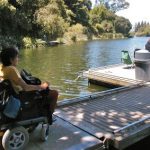
A park shuttle leaves daily (except Tues. & Wed.) from the parking lot to the pier. It is not wheelchair lift-equipped; however, with advance notice you can follow the shuttle in your vehicle and park near the pier. - Accessible Restroom: Yes
The most accessible restroom is by the northern shuttle stop and at the start of the pier. Portable units are at the Point Pinole trailhead, intersection of Cook’s Point Trail and Owl Alley Trail, and at Palms and Giant Cluster picnic areas. - Accessible Picnic Tables: Yes
One quarter mile from the parking area, and at the fishing pier.
Other Things of Interest
No fishing license is required to fish from the pier (1.5 miles from the parking area). Some benches on the pier have windbreaks, and are designed with space for wheelchairs. A wooden rail at 42″ high, may obstruct views for wheelchair users.
Additional Information
- Map: See here.
- Hours: 5 am-10 pm unless otherwise posted
- Fees: Parking, fee per dog; no fees when kiosk is closed
- Dogs: On a leash
I has worked for more than 30 years advocating for, and educating about access to outdoor recreation and tourism for people with disabilities. I hold a degree in Recreation Therapy and was a travel agent specializing in accessible travel for many years. In this capacity, and now as Associate Director at Wheelchair Traveling, I consult with the travel industry about accessibility, conducts disability awareness trainings and writes about travel and outdoor recreation. I also authored a book titled, A Wheelchair Rider's Guide: San Francisco Bay and the Nearby Coast, about accessible trails and has produced several access guides to San Francisco. My most current project is a website of accessible trails along the entire California Coast (www.wheelingcalscoast.org). My extensive experience as a wheelchair rider combined with her professional experience has provided me with in-depth knowledge about inclusive tourism and outdoor recreation.